To a large degree, my active research
projects mirror those of my graduate students.
Read on to learn about the recent activities of our research group.
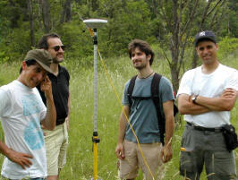
Summary: The M5.8 Mineral,
VA earthquake of 24 August, 2011 was a sobering reminder of how
little we really understand about intraplate seismicity, and
specifically, the geologic, geodynamic, and gephysical processes
that drive intraplate seismicity in the central and eastern
U.S. Along with colleagues Anne
Meltzer (Lehigh, seismology), Bill
Holt (SUNY Stony Brook geodynamics), Seth
Stein (Northwestern, geodesy, seismology, earthquake hazards),
Claudio
Berti (Idaho Geologic Survey, tectonic geomorphology), Helen Malenda, and Josh Gonzales (UNLV Civil Engineering) we aim
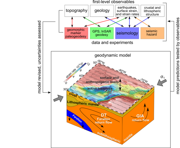
to define a systems-level description of CEUS intraplate seismicity
(Figure 1), and test that conceptual framework with geodynamic
models that predict stress concentrations (Figure 2). The
predictions made by the geodynamic models are testable with
lithospheric revealed by a strategically located, dense seismic
network (Figure 3) and GPS, InSAR, and geomorphic geodetic
observables (Figure 4). I view this as a great continuing
venue for new graduate student research projects.
Figure 1 (left). Conceptual, systems-level framework of
CEUS lithospheric and
sub-lithospheric components, linkages,
and processes.
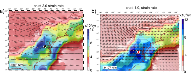
Figure 2 (right). Modeled strain rate(blue=high strain)
for two different crustal thickness models. In both
cases, the Appalachian
lithosphere has a lower model viscosity than the craton or
Atlantic ocean. (Bill Holt).
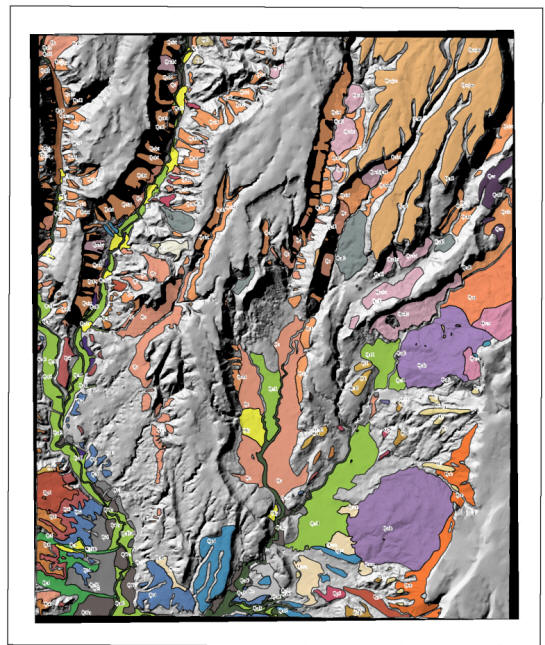
Figure
3. Location of the Mineral earthquake and South Anna River
basin, focus of our recent studies (Pazzaglia et al., 2021,
Journal of Geology).
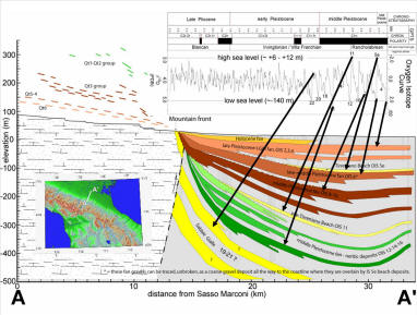
Figure 3. (a) Long
profile of the South Anna River showing the extent of the
study area. Actual
profile from 10-m DEM in white, smooth profile in dark blue.
Dashed green line shows downstream projection of upper profile
to Choptank Fm intersection on the inner Coastal Plain. Black dotted
line is channel steepness (ksn) calculated using Eq. 2. Open
circles are ksn values
calculated over 5 km-long reaches using linear inversion of
all South Anna basin channels draining an area > 1 km2. The short, solid black curve
is a polynomial fit to these ksn data through the study reach. Gray shaded
curve shows the range of channel response time (Eq. 4) using the
minimum and maximum ksnand Kvalues and corresponding arrows indicate
the age range for the channel at km 170. Red shaded
line is the range of predicted steady-state channel elevations
(Eq. 5) using
minimum and maximum ksn values. Channel steepness in this plot
uses a θref = -0.48
Locations keyed to Figures 2 and 4 are same as in Figure 2.Geology
traversed by the channel shown in rectangles at the base of
the plot with geologic symbols same as in Figure 2a. Location
symbols and
extent
of study reach as in Figure 2b, but the length of the upstream,
epicentral, and downstream reaches are longer in this plot
because the x-axis is channel distance, not linear distance between
A-A.(b)
Topographic swath profiles parallel and transverse to the
South Anna River. The red line is the mean elevation. (c) chi (χ) and (d) normalized
channel steepness (ksn) of the South
Anna and surrounding rivers from a 90-m DEM base and a θref = -0.45.
Figure 5. (a)
Location map of the Pennsylvania Piedmont study area, underlying
geology (USGS) and associated seismicity of the Reading-Lancaster
seismic zone (USGS CEUS catalog
https://www.sciencebase.gov/catalog/item/5ad7709ce4b0e2c2dd25649c).
Watersheds: L1-Pequea Creek, L2-
Tucquan Creek, L3- Kellys Run, L4-Wissler Run,
L5- Fishing Creek, Y1- Otter Creek, Y2- Sawmill Run, Y3-
Counselman Run, Y4- Duncan Run, Y5- Oakland Run, Y6- Mill
Creek, Y7- Anderson Creek, Y8- Muddy Creek. Highlighted is
the magnitude 4.3 1984 Lancaster earthquake, which
occurred at a depth of 4.5 km on a NNE trending steeply
East dipping fault plane (Armbruster and Seeber, 1985;
Stockar, 1986). SHD- Safe Harbor Dam, HD- Holtwood Dam.
The Tucquan (Freedman et al., 1964) and Westminster
(Cambell, 1929) anticlines are Paleozoic structural and
Cenozoic topographic features, respectively. Inset:
Location of Reading-Lancaster Seismic Zone (RLSZ) and
Central Virginia Seismic Zone (CVSZ). (b) Otter Creek and Tucquan
Creek catchments are situated on opposing banks of the
Susquehanna River and have experienced the same base level
fall histories at their mouth. Tucquan Creek drains a
portion of Lancaster County proximal to the RLSZ,
including the 1983 Lancaster earthquake. Comparable
seismicity is lacking beneath otter Creek and in York
County PA in general. The steepness (ksn) of the main channels in these
watersheds shows that the channels are steepest near their
mouths, but that there are several other steep reaches, or knickpoints
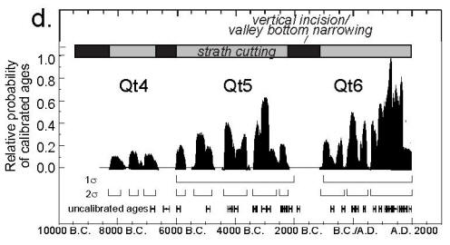
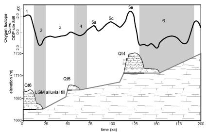
Figure 6.
Response times (gray lines) and model predicted channel
elevation (green lines) based on the longitudinal profiles
of Fig. 7 and a catchment
uniform ksnand K.
The elevation of several knickpoints
in the Tucquan Creek channel do not have a
corresponding-elevation knickpoint in the Otter Creek
drainage, consistent with more rock uplift beneath Tucquan
Creek, as envisioned in Fig.
5 above.
Modeled knickpoint response times are consistent with the
history of base level fall and stratigraphic markers
preserved in the Lower Susquehanna River basin (Pazzaglia,
1993; Pazzaglia and Gardner, 1993).
So...we
have some really fascinating results emerging from a response time
model for streams draining the Appalachian Piedmont that we can test
against what we know about deformed geomorphic markers, like terraces
and transient knickpoints. This is all of the work of Helen
Malenda, Matt McGavick, and Josh Gonzales.
Papers:
Wolin,
E., Stein, S., Pazzaglia, F. J., Meltzer, A., Kafka, A., and Berti,
C., 2012, Mineral, Virginia
earthquake illustrates seismicity of a passive-aggressive margin:
Geophysical Research Letters, 39, doi:10.1029/2011GL050310. PDF
Berti,
C., Pazzaglia, F. J., Meltzer, A. S., and Harrison, R. J., 2014,
Geomorphic evidence for persistent, cumulative deformation of the
Virginia Piedmont in the vicinity of the 23 August, 2011 Mineral
earthquake: Geological Society of America Special Paper, 509,
doi:10.1130/2015.2509(21). PDF
Malenda,
H., 2015, New Quaternary
geochronometric constraints on river incision in the Virginia
Piedmont: Relative contributions of climate, base level fall,
knickpoint retreat, and active tectonics: M.S. Thesis, Bethlehem, PA,
89 p. PDF
Pazzaglia,
F. J. and Carter, M., 2015,
Geomorphology, active tectonics, and landscape evolution in the
Mid-Atlantic Region, in Brezinski, D. K., Halka, J. P., and Ortt, R.
A. Jr., eds., Tripping from the Fall Line: Field Excursions for the
GSA Annual Meeting, Baltimore, 2015, Geological Society of America
Field Guide FLD40.Non-copyedited
Pre-Print.
Pazzaglia, F. J.
and Gonzales, J. M., 2020, RIver knickpoint paleogeodesy and
measurement of crustal deformation in the Central Virginia seismic
zone (CVSZ) and Reading Lancaster seismic zone (RLSZ): Report for USGS
Award G18AP00061. PDF
Pazzaglia, F. J., Malenda, H.F.,
McGavick, M. L., Raup, C., Carter, M.W., Berti, C., Mahan, S.,
Nelson, M., Rittenour, T.M., Counts, R., Willenbring, J.,
Germanoski, D., Peters, S. C., and Holt, W.D., 2021, River terrace
evidence of tectonic processes in the eastern North American plate
interior, South Anna River, Virginia: Journal of Geology, 000,
000-000. PDF
Summary: Well...Italy is a
pretty spectacular place, geology and active tectonics
notwithstanding. I have two active areas of interest in Italy:
(1)
Along with my post-doc Francesco
Pavano, colleagues at the University of
Catania in the research group of Stefano
Catalano, and colleagues in the research group of Sean Gallen at CSU, we are looking to learn
more about the steadiness of tectonic forcing, geomorphic response,
erosion rates over Pleistocene time scales, and the non-linear
relationship between erosion and normalized steepness of long
profiles in northeast Sicily. We remain enthusiastic about
what we can learn from this remarkable island located in a complex
plate boundary setting. Bestiale! There are
emerging opportunities here for graduate research.
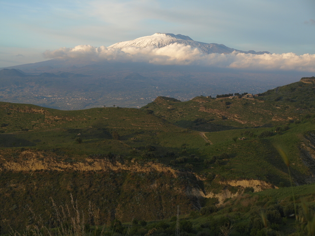
Etna, looking east
from central Sicily, near Enna.
Map showing
tectonic setting of Sicily.
Marine terraces cut into the footwall of the Taormina fault, NE
Sicily.
Results of a knickpoint celerity model that compares the modeled
position of a channel knickpoint (open stars) assuming a
marine-terrace correlative age, to the actual location of a knickpoint
along the channel. The excellent correspondence indicates that
we know the amount of channel incision and volumes of rock removal
from the drainage basins over late Pleistocene time scales.
Franceso Pavano and Sean Gallen have teamed up here to track the passage
of the Calabrian forearc, using the history of base level fall, and
response time of the catchments along the northern coast of Sicily.
Note the younging of two knickpoints, common to all of the
northern-shore catchments, towards the east. Also note the
increase in river incision towards the east.
(2)Along
with my colleagues at a number of universities and research centers,
including Fausto Pazzaglia at IntGeoMod,
I have a long-standing research interest in the Tectonic
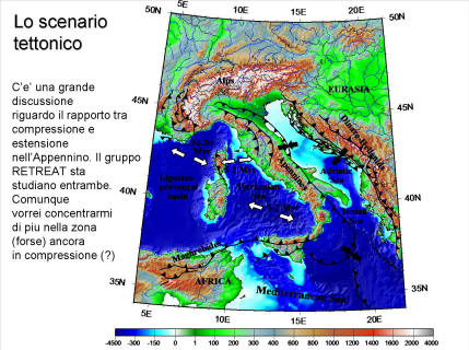
Geomorphology of central Italy. Italy is the active plate
boundary between Adria and Europe. In addition, there is a
Quaternary dynamic support of the high topography of the
Apennines. All of this combines to generate active
compressional and extensional faults in close proximity. You
can learn a lot from language and regional dialects. In central
Italy they say: "Norcia, Cascia, e Vissu, Dio li creo', e
Dio li maledissu', ma nella valle di San Clemente sgrulla sgrulla
ma nun casca gnente". This tell you where the
earthquakes are really bad, the places like Norcia, Cascia, and Visso,
where God creates them and God curses them, and where the earthquakes
are felt, but do not knock things down, like the Valley of San
Clemente in the Marche. Except, historically, there have been some
really large earthquakes in the Marche (large orange circles below),
but the causitive faults are not well known. I seek to combine
tectonic geomorphology, structural geology, and cyclostratigraphy,
with novel application of anisotropy of magnetic susceptibility (AMS)
rock fabrics to test contrasting geometries and kinematics of
seismogenic faults with little to no surface expression in central
Italy. Here, the Alto-Tiberina fault offers a natural laboratory to
study kinematics at the orogen scale for a demonstrably slipping,
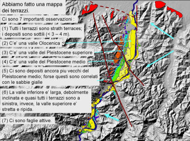
low-angle detachment.
The photo below is a panorama of Pian Grande at Castelluccio,
Italy. The photo of the beautiful place was taken just two
weeks before the devastating sequence of earthquakes on large normal
faults that has resulted in hundreds of deaths, serious damage to
critical infrastructure, and irrevocable cultural history losses in
the Apennines of central Italy.
Here
is the fault that ruptured in August at M 6.2.
Segments
both north and south of this fault ruptured through January,
2017. The entire seismic sequence is visualized here:
Geodynamic
models proposed to explain the seismicity in central Italy, such
as the one forwarded by
our work in the northern Apennines, or in a recent Terra
Nova paper, can be tested using tectonic
geomorphology. Here is a recent application of a linear
inversion of fluvial topography to test models for the development of
transverse drainages throughout the Italian Peninsula. This work
has been completed with MS student James Fisher.
(Left)
Italian Peninsula showing catchments (in red) where the base level
fall history have been reconstructed by a linear inversion of
fluvial topography. (Right)Combined
median τ-U plots for the (a) northern Apennine, (b) central
Apennine, and (c) southern Apennine catchments, with accompanied
representative χ-z plots and the cumulative uplift curves for a
representative catchment for the past 3 Ma.
Transparent red line is the respective mean τ-U.
This mean does not include the Tronto catchment in (b). P
= possible examples of stream piracy and loss of drainage area; C =
possible examples of stream capture and growth of drainage area.
Papers:
Pavano,
F., Pazzaglia, F. J., and Catalano, S., 2016, Knickpoints as
geomorphic markers of active tectonics: A case study from northeastern
Sicily (southern Italy): Lithosphere, 8, 633-648. PDF
Pavano,
F. and Gallen, S. F., in press, A geomorphic examination of
the Calabrian Forearc Translation: Tectonics, 000, 000-000.
Pazzaglia,
F. J. and
Fisher, J., 2021, A
reconstruction of Apennine uplift history and the development of
transverse drainages from longitudinal profile inversion, in
Koeberl, C., Claeys, P., and Montanari, S., eds, From the Guajira
desert to the Apennines, and from Mediterranean microplates to the
Mexican killer asteroid: Geological Society of America Special
Paper 000, 000-000. PDF
Summary: The fluvial
stratigraphy of the Appalachian Piedmont and Inner Coastal Plain, long
a research interest of mine, has a renewed focus given the detailed
investigations of the South Anna River following the Mineral
Earthquake in 2011. New OSL ages are helping build a complex
stratigraphy of this slowly eroding landscape where river incision
appears to be growing relief against a backdrop of epeirogeny,
eustatic fall, and local intraplate seismicity. Me and my
colleagues including Mark
Carter and Helen
Malenda (USGS), Tammy
Rittenour (Utah State), and Jane
Willenbring (Stanford) have a growing research agenda here with
many opportunities for graduate students.
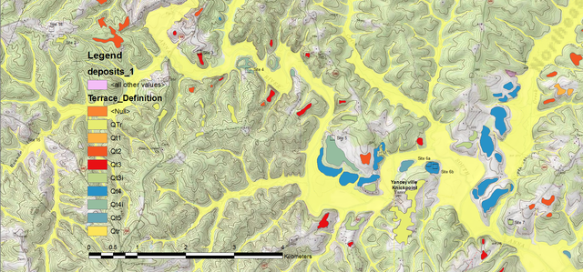
1:24,000 scale geologic mapping of river terraces (in red) by M.S.
student Helen Malenda along the South Anna River provides the
foundational observations for building a Piedmont fluvial
stratigraphic model.
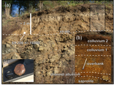
Excellent exposures of terrace alluvium, like this one at Virginia
Vermiculite, provide material for OSL ages.
That
leads to constructing a fluvial stratigraphy on the footwall (top)
and hanging wall (bottom) of the fault that ruptured in the 2011
earthquake.
And
a final correlation of the terraces, showing a growth anticline near
the surface projection of the earthquake rupture (HFR).
Papers:
Berti,
C., Pazzaglia, F. J., Meltzer, A. S., and Harrison, R. J., 2014,
Geomorphic evidence for persistent, cumulative deformation of the
Virginia Piedmont in the vicinity of the 23 August, 2011 Mineral
earthquake: Geological Society of America Special Paper, 509,
doi:10.1130/2015.2509(21). PDF
Pazzaglia,
F. J. and Carter, M., 2015,
Geomorphology, active tectonics, and landscape evolution in the
Mid-Atlantic Region, in Brezinski, D. K., Halka, J. P., and Ortt, R.
A. Jr., eds., Tripping from the Fall Line: Field Excursions for the
GSA Annual Meeting, Baltimore, 2015, Geological Society of America
Field Guide FLD40. Non-copyedited
Pre-Print.
Pazzaglia, F. J., Malenda, H.F.,
McGavick, M. L., Raup, C., Carter, M.W., Berti, C., Mahan, S.,
Nelson, M., Rittenour, T.M., Counts, R., Willenbring, J.,
Germanoski, D., Peters, S. C., and Holt, W.D., 2021, River terrace
evidence of tectonic processes in the eastern North American plate
interior, South Anna River, Virginia: Journal of Geology, 000,
000-000. PDF
Summary: In all of the
landscapes that I have worked, I have been fascinated by the
Neogene-Quaternary stratigraphy, sedimentology, and (paleo)soils of
mostly unconsolidated deposits and the implications these deposits
have for paleoenvironments and paleoclimates. In a warming world
where CO2 levels are at 400 ppm and climbing, it is not
lost on anyone that super interglacials of the middle Pleistocene,
perhaps like OIS 11, and pre-glacial warm periods, like the middle
Pliocene, are good analogs for the world our kids and grandkids are
going to inherit. The more we learn about these
paleoenvironments now, the better prepared we are for what seems to be
a warmer future. Along with my college Steve
Peters (Lehigh, geochemistry) and M.S. student Laura Markley, we
are beginning to explore paleoenvironmental conditions of the middle
Pleistocene and Mio-Pliocene for ancient deposits preserved in the
Appalachians and on the Inner Coastal Plain of the mid-Atlantic
region. We are looking for more students who want to pursue
similar projects.
Oblique-air
view, from Google Earth, of an alluvial fan spilling out of South
Mountain onto the floor of the Great Valley, at Mainsville, PA.
Gravel quarry operations offer access to the Neogene-Quaternary
stratigraphy of these Appalachian surficial deposits.
Sedimentology,
stratigraphy, soils, and geochemistry of Mainsville fan
deposits. The oxylate iron (FeO) to dithinoite iron (FeD) ratio
is a relative measure of pedogenic iron crystallinity, and hence, soil
age.
Comparison
of the FeO/FeD ratio for a number of soils formed in old alluvium
and colluvium in the Mid-Atlantic region (gray bars). The
Mainsville deposits are labeled MV.
Click
to download a summary poster of our data, presented at the 2019 Amtrak
Conference at F&M.
Papers:
Pazzaglia,
F. J., Robinson, R., and Traverse, A., 1997,
Palynology of the Bryn Mawr Formation (Miocene): Insights on the age
and genesis of middle Atlantic margin fluvial deposits: Sedimentary
Geology, v. 108, p. 19-44. PDF
Pederson,
J. P., Pazzaglia, F. J., and Smith, G., 2000,
Ancient hillslope deposits: Missing links in the study of climate
controls on sedimentation: Geology, v. 28, p. 27-30. PDF
Pederson,
J. L., Smith, G. A., and Pazzaglia, F. J., 2001,
Comparing the modern, Quaternary, and Neogene records of
climate-controlled hillslope sedimentation in Southeast Nevada:
Geological Society of America Bulletin, v. 113, no. 3, p. 305-319. PDF
Pazzaglia, F. J. and
Hawley, J. W., 2004, Neogene
(rift flank) and Quaternary geology and Geomorphology in, Mack, G. and
Giles, K., eds., The Geology of New Mexico: New Mexico Geological
Society Special Publication 11, Albuquerque, NM, p. 407-437. PDFPDF
Pazzaglia, F. J., 2014,
Brief thoughts on long-term landscape evolution in the mid-Atlantic
region with a focus on the Pond Bank lignite, in Anthony, R.,
Pennsylvania's Great Valley and bordering mountains near Carlisle:
Guidebook, 79 th Annual Field Conference of Pennsylvania Geologists,
23-34. PDF
Pazzaglia, F. J., Peters,
S. C., and Cummins, K. T., 2014,
Late Cenozoic sedimentology, stratigraphy, and pedogenesis of the
Furnace Creek fan exposed in the Valley Quarries pit, Mainsville, PA,
in Anthony, R., Pennsylvania's Great Valley and bordering mountains
near Carlisle: Guidebook, 79 th Annual Field Conference of
Pennsylvania Geologists, 101-112. PDF
Blake, J. M., Dykman, J.
N., Peters, S. C., and Pazzaglia, F.J., in
prep., A pedologic, geomorphic, and geochemical approach to
understanding weathering in the Critical Zone in central PA.
Summary:
Rivers and terraces represent the core data set that my students and I
collect to understand landscape evolution, climate change, and active
tectonics. I am interested in working with any student that
wants to forward our understanding of how rivers make terraces and
what modulated unsteadiness in river incision. I am particularly
interested in modeling the processes that carve straths. This
research involves a good deal of field work and integration of
Quaternary geochronology such as OSL and cosmogenics. I have
numerous collaborators on these projects, all listed as co-authors in
the publications below.
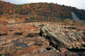
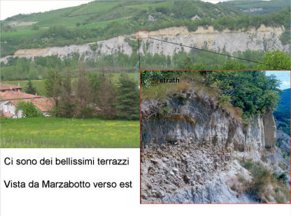
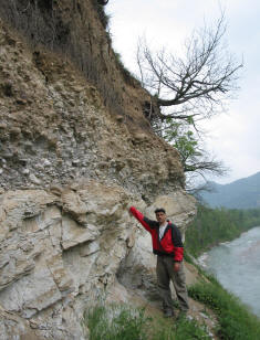
Photos
from left: strath and strath terrace at Marzabotto, Italy; outwash
terraces in from Snake River Overlook, Grand Teton N.P.; straths and
strath terraces, Holtwood Gorge, Susquehanna River, PA; terraces of
the Jemez valley, New Mexico.
(Left)
Holocene strath forming intervals for the Clearwater River,
Washington State.
(Right) Terrace formation and long-term incision for the
Jemez River, New Mexico.
We
have an on-going research project in southwestern PA, using the
Youghiogheny River and Ohiopyle State Park to investigate terrace
genesis, correlation, and base level fall (uplift) of the Laurel
Highlands. This work involves a large collaborative effort with
the PA Geological Survey and Ohiopyle State Park to understand the
origin and evolution of waterfalls and rapids of the Youghiogheny
River. New cosmogenic exposure, burial, and isochron ages as
well as steady-state erosion rates constrain linear inversion models
of fluvial topography and shed new light on the age of Glacial Lake
Monongahela and the Carmichaels Formation.
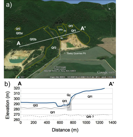
(Left)
(a) Geologic map of southwestern PA around the Youghiogheny
River. (b) inset detail of Ohiopyle State Park. (c) Exposure
of Carmichaels Fm fluvial-lacustrine facies. (d) Photo of Ohiopyle
Falls. (Right) Map of terraces and TCN ages in the
Ohiopyle-Ferncliff region.
Proposed
correlation of terraces along the Yoghiogheny River, showing offset
related to ongling uplift of the Laurel Highlands relative to the
Pittsburgh low plateau. (from Kurak et al., 2021).
Papers:
Gardner,
T. W., Hare, P. W., Pazzaglia, F. J., and Sasowsky, I. D., 1987,
Evolution of drainage systems along a convergent plate margin, Pacific
Coast, Costa Rica, in Graf, W. L., ed., Geomorphic systems of North
America: The Geology of North America, Decade of North American
Geology, Geological Society of America, special centennial volume 2,
Boulder, Colorado, p. 357-372. PDF
Pazzaglia,
F. J.
and Gardner, T. W., 1993,
Fluvial terraces of the lower Susquehanna River:
Geomorphology, v.8, p.83-113.
PDF
Formento-Trigilio,
M. L. and Pazzaglia, F.J., 1998,
Tectonic geomorphology of Sierra Nacimiento; traditional and new
techniques in assessing long-term landscape evolution of the southern
Rocky Mountains: Journal of Geology, v. 106, p. 433-453. PDF
Pazzaglia,
F. J.,
Gardner, T. W., and Merritts, D., 1998,
Bedrock fluvial incision and longitudinal profile development over
geologic time scales determined by fluvial terraces, in
Wohl, E. and Tinkler, K., eds., Bedrock Channels: American Geophysical
Union, Geophysical Monograph Series, v. 107, p. 207-235.
PDF
Zaprowski,
B. J., Evenson, E. B., Pazzaglia, F. J., and Epstein, J., 2001,
Knickzone propagation in the Black Hills and northern High Plains; a
different perspective on the late Cenozoic exhumation of the Laramide
Rocky Mountains: Geology, v. 29, no. 6, p. 547-550. PDF
Pazzaglia,
F. J.
and Brandon, M. T., 2001,
A fluvial record of long-term steady-state uplift and erosion across
the Cascadia forearc high, western WashingtonState:
American Journal of Science, v. 301, no. 4-5, p. 385-43. PDF
Wegmann
K. and Pazzaglia, F. J., 2002,
Holocene strath terraces, climate change, and active tectonics: the ClearwaterRiver basin, Olympic
Peninsula, Washington State: Geological Society of America Bulletin,
v. 114, n.6, p. 731-744.
PDF
Wisniewski, P. and Pazzaglia,
F. J., 2002, Epeirogenic
controls on Canadian River incision and landscape evolution, High Plains
of northeastern New Mexico: Journal of Geology, v. 110, n. 4, p.
437-456. PDF
Tomkin, J.H., Brandon, M.T.,
Pazzaglia, F.J., Barbour, J.R., Willett, S.D., 2003,
Quantitative testing of bedrock incision models, Clearwater River, NW
Washington State, Journal of Geophysical Research, v. 108, no. B6, 2308,
doi:10.1029/2001JB000862. PDF
Etheredge, D., Gutzler, D.
S., and Pazzaglia, F. J., 2004,
Geomorphic response to seasonal variations in rainfall in the Southwest
United States: Geological Society of America Bulletin, v. 116, p.
606-618. PDF
Pearce, S. A., Pazzaglia, F.
J., and Eppes, M. C., 2004,
Ephemeral stream response to growing folds: Geological Society of
America Bulletin, v. 116, p. 1223-1239. PDF
Pazzaglia, F. J., 2005,
River responses to Ice Age (Quaternary) climates in New Mexico, in
Lucas, S. G., Morgan, G. S., and Zeigler, K. E., eds., New Mexicos Ice
Ages: New Mexico Museum of Natural History and Science Bulletin No 28.,
p. 115-124. PDF
Zaprowski, B., Pazzaglia, F.
J., and Evenson, E. B., 2005,
Climatic influences on profile concavity and river incision: Journal of
Geophysical Research Earth Surface, v. 110, F03004,
doi:10.1029/2004JF000138. PDF
Pazzaglia, F. J., J.
Selverstone, M. Roy, K Steffen, S. Newland-Pearce, W. Knipscher, and J.
Pearce, 2007, Geomorphic
expression of midcrustal extension in convergent orogens: Tectonics, 26,
TC6010, doi:10.1029/2006TC001961. PDF
Wegmann, K. and Pazzaglia, F.
J., 2009,
Late Quaternary fluvial terraces of the Romagna and Marche Apennines,
Italy: Climatic, lithologic, and tectonic controls on terrace genesis in
an active orogen: Quaternary Science Reviews, 28, 137-165.
PDF
Pazzaglia F.J., 2013,
Fluvial Terraces, in, John F. Shroder (Editor-in-chief), Wohl, E.
(Volume Editor), Treatise on Geomorphology, Vol 9, Fluvial
Geomorphology, San Diego: Academic Press, p. 379-412. PDF
Gallen, S. F.,
Pazzaglia, F.J., Wegmann, K.W., Pederson, J.L., Gardner, T.W., 2015,
The dynamic reference frame of rivers and apparent transience in
incision rates: Geology,v. 43, no. 43, p. 623-626,
doi:10.1130/G36692.1. PDF
Schmidt, J. L., Zeitler, P. K.,
Pazzaglia, F. J., Tremblay,
M. M., Schuster, D. L., and Fox, M., 2015, Knickpoint evolution on the
Yarlung River: Evidence for late Cenozoic uplift of the
southeastern Tibet plateau margin: Earth and Planetary Science
Letters, 430, 448-457. PDF
Sembroni, A., Molin, P., Pazzaglia, F. J., Faccenna, C., and Abebe, B., 2016, Evolution of
continental-scale drainage in response to mantle dynamics and
surface processes: An example from the Ethiopian Highlands:
Geomorphology, 261, 12-29. PDF
Kurak,
E., Pazzaglia, F. J., Li, C.X., Patching, A., Shaulis, J., Corbett,
L., Bierman, P., Nelson, M., and Rittenour, T., 2021, Incision
of
the Youghiogheny River through the Laurel Highlands determined
by a new river terrace stratigraphic age model, Ohiopyle State
Park, southwestern Pennsylvania: Guidebook, 85th
Field Conference of PA geologists. PDF
Pazzaglia,
F. J., in press - 2022, Fluvial Terraces, in Shroder, J., (Editor-in-chief), Wohl, E. (Volume
Editor), Treatise on Geomorphology, second edition, v. 9, Fluvial
Geomorphology, Elsevier Academic Press. PDF
Parallel Process Studies: I have had a
long-standing research interest in the Pacific Northwest (see
Pazzaglia and Brandon, 2001, Wegmann and Pazzaglia, 2002, Tomkin et
al., 2003) and our most recent foray to this great field location is
to use cosmogenics and sediment gauge data to unravel sediment
transport rates, watershed-scale erosion rates, and hillslope
processes. The key goal in this research is to document and
quantify the strong suspicion that the erosion rate you measure based
on the inventory of cosmogenic 10Be in stream alluvium depends on the
grain size fraction investigated. This grain size effect is
linked to the distribution of hillslope processes in a
watershed. We are once again investigating the Clearwater
drainage basin because we have good independent estimates for what the
long-term erosion rates should be and we can rather simply understand
the spatial distribution of creep-dominated vs. landslide dominated
hillslopes. My collaborators on these projects are Patrick
Belmont, John
Gosse, Ed Evenson, and Mark
Brandon.
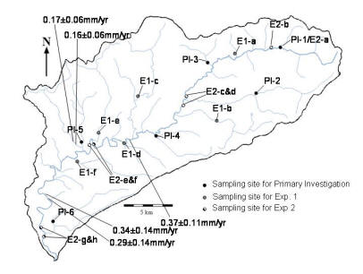
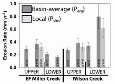
Left: The Clearwater basin,
sampling locations, and preliminary erosion rates. Right:
Erosion rates for Miller and Wilson creeks. Note the
differences in rates as a function of grain size and sampling
location (headwaters vs stream mouth). Detailed interpretation
of these data are explained below in the Belmont et al publication.
Papers:
Pearce, J. P., Pazzaglia, F.
J., Evenson, E. B., Germanoski, D., Alley, R., Lawson, D., and Denner,
J., 2003, Bedload component of
glacially discharged sediment: Insights from the Matanuska Glacier:
Geology, v. 31, p. 7-10. PDF
Belmont, P., Pazzaglia, F. J., and
Gosse, J. C., 2007, Cosmogenic 10Be as a tracer for
hillslope and channel sediment dynamics: Earth and Planetary Science
Letters, 264, 123-135. PDF
Summary:
We are able to document unsteadiness in the growth of folds cored by
blind thrusts along the Apennine mountain front. We have
discovered that the magnetic susceptibility in a section of
Messinian-Pleistocene marine mudstone varies at Milankovitch
frequencies, allowing us to see unsteadiness in fault slip and growth
strata tilt at 23, 41, and 100 kyr timescales. This study
provides a rare opportunity to link unsteadiness at geologic and
geodetic scales. We are in the process of comparing the
unsteadiness of two unconnected structures to see if there are any
feedbacks and temporal overlap caused presumably by surficial
processes. We are also trying to understand how these magnetic
signals and Milankovitch fidelity are being encoded into the
rocks. I am doing the research collaboratively with Dave Anastasio, Ken Kodama, Andrea Artoni, and
Vincenzo Picotti. All of this work is part of the Ph.D.
dissertation of Kellen
Gunderson, and the MS work of Katrina Gelwick.
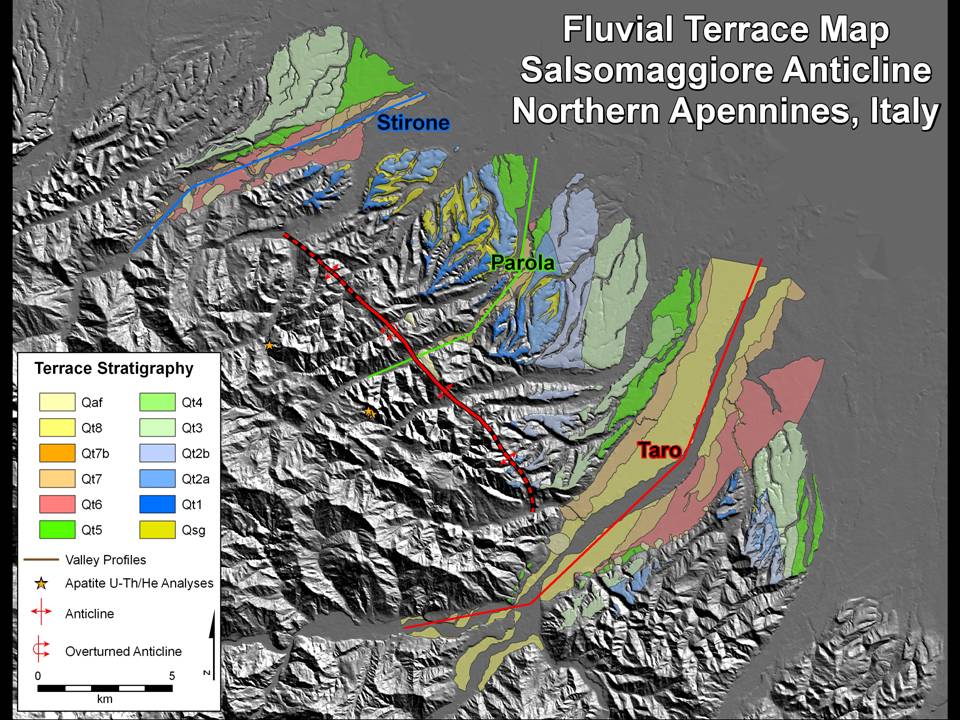
Left to Right: Example of growth strata exposed in the Stirone River,
variability in magnetic susceptibility and the geomagnetic time scale,
and Milankovitch-tuned folding unsteadiness.
(left)
Growth strata along the Enza River, San Paolo d'Enza, Italy. (right)
Measured section, rock magnetic susceptibility, and obliquity
periodicity. The dashed lines indicate a possible tuning
of the MS record that argues for a steady sediment accumulation
rate. The red lines indicate a possible tuning of the MS
record assuming unsteady sediment accumulation and hiatuses,
represented by the soils and unconformities. (from the M.S.
thesis of Katrina Gelwick).
Our
most recent, NSF-funded project along with my colleagues Francesco Pavano, Stefano
Catalano, Nicole
Gasparini, Tammy
Rittenour, and MS student Ben Bliss. We have defined a
study site in northeastern Sicily that offers an excellent
opportunity to explore the encoding of exogenic and autogenic
geomorphic processes recorded (or not) in sedimentary
sequences. Here is an outcrop that we suspect represents at
least two inset fan-delta complexes deposited during eustatic
highstands during the middle to late Pleistocene. The
deposits on the left represent distributary mouth bars and
channels and are part of the older fan-delta that we suspect to be
MIS 7.1 in age. The deposit on the right, inset against the
buttress unconformity are the fluvial facies of a younger
fan-delta that we suspect to be related to MIS 5.5.
We
are able to directly link these deposits back to the watershed
that delivered the sediment, so it is a small, well constrained,
source to sink system.
The
fan delta deposits are rhythmically-bedded. We do not know
why, especially since common autogenic processes like delta-lobe
switching should be stochastic and effectively shred any exogenic
forcing. But, clearly, there is a cylclicity in the
bedding. We do not yet know the time represented by our
measured section, but with pending OSL geochronology, we should be
able to link this cyclicity to known exogenic or autogenic
forcings in the watershed. We have a proposal pending at NSF
to do just that.
Left:
Part of the Pagliara fan-delta measured section that has been
sampled for OSL geochronology and magnetic susceptibility.
The rock-mag samples are collected every 20 cm and analyzed at
Lehigh paleomagnetism laboratory under the direction of Ken
Kodama. Right: Spectral analysis of the
magnetic susceptibility of the Pagliara fan-delta samples.
Clearly, there is a repeating pattern of magnetite abundance or
grain size every 60 cm. If we assume that the entire
fan-delta was deposited in 20 ka, the average sedimentation rate
would be 1.25 cm/yr, and a 60 cm cycle would correspond to 48
years. If we assume 10 ka for the entire fan-delta, the
average sedimentation rate is 2.5 cm/yr and a 60 cm cycle
corresponds to 24 years. We purposely sampled at a high
frequency to see if cyclicity could be preserved at the scale
where autocyclic shredding should be going on. Evidently,
it is preserved. Now it would be good to understand why
this fan-delta system generates decadal-scale cyclicity.
Is it lobe-switching, or is is runoff variations, or something
else?
We
are comparing the results of the Pagliara delta to other settings,
both tectonically active and stable. These include a kame
delta in tectonicaly stable eastern Pennsylvania (Bliss, 2021, MS
thesis), and a Provo-stage delta of Glacial Lake Bonneville in
northern Utah, that was constructed along the tectonically active
East Cache Valley fault. This Provo delta experineced at
least one syn-depositional earthquake with a surface rupture.
(Left)
Measured section and MS and grainsize timeseries of the Sicota
kame delta in eastern PA. (Right) Measuring section
in the Allen Pit for a Provo stage delta along the East Cache
Valley fault system. Both of these deltas exhibit similar
multi-decadal scale cyclicity despite the different tectonic
setting and sediment source.
Papers:
Gunderson, K. L., Pazzaglia, F. J.,
Picotti, V., Anastasio, D. J., Kodama, K. P., Rittenour, T.,
Franke, K. F., Ponza, A., Berti, C., Negri, A., and Sabbatini, A.,
2014, Unraveling tectonic and climatic controls on
synorogenic stratigraphy: Geological Society of America Bulletin,
126, 532-552. PDF
Gunderson,
K. L., Anastasio, D. J., Pazzaglia, F. J., and Picotti, V., 2013,
Fault slip rate variability on 104-105 yr
timescales for the Salsomaggiore blind thrust fault, Northern
Apennines, Italy: Tectonophysics, 609, 356-365. PDF
Gunderson,
K. L., Anastasio, D. J., Kodama, K. P., and Pazzaglia, F. J., 2012,
Rock-magnetic cyclostratigraphy for the late Pleistocene Stirone
section, northern Apennine mountain front, Italy, in Jovane, L.,
Housen, B., Herrero-Berrera, E., and Hinnov, L., eds., Temporal
variation of geological processes revealed by magnetic methods:
Geological Society of London, Special Publication 373,
doi:10.1144/SP373.8 PDF
Gunderson,
K. L., Anastasio, D. J., Pazzaglia, F. J., and Kodama, K. P., 2018,
Intrinsically variable blind thrust faulting: Tectonics, 37,
doi:10.1029/2017TC004917 PDF
I
have had the amazing opportunity to travel to Mongolia in the summers
of 2017 and 2019, working with Lehigh colleagues Anne S Meltzer and
Peter K. Zeitler and colleagues at the Geophysics Institute in
Ulaanbaatar, Mongolia to explore the active tectonics, and Cenozoic
landscape and tectonic development of this incredible geologic
wonderland. The results of my contributions to this research and
nice summary of what we are trying to do is summarized here, in this
poster presented at the GSA 2020 annual meeting.
Summary: The
Appalachian Mountains provide a setting where we can investigate the
long-term erosion of an orogen that has persisted for hundreds of
millions of years. We link geomorphic studies using field and
GIS/DEM data with apatite U-Th/He thermochronologic studies. What
we are learning is that long-term rates of erosion have been very slow
in the Appalachians and are probably characterized by rates on the order
of 10 to 20 m/m.y. The Appalachian landscape continues to evolve,
as indicated by non-steady shifts in drainage divides between major
transverse rivers, but the lag-times in such a slowly eroding system are
so large, that there exists a wide range of fluvial
disequilibrium. We are currently testing the possibility that
large volumes of late Tertiary offshore sediment are link primarily to
these drainage-divide adjustments, perhaps linked to a geodynamic
process, rather than global climate change. I'm conducting this
research with Peter
Zeitler,Bruce
Idleman, Ryan McKeon,
and Eva Enkelmann. Check out our latest paper below with Andrew Moodie on continental divide mobility
applied in the Appalachians.
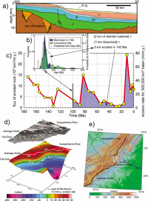
History of post-orogenic erosion in the Appalachians
illustrating unsteadiness and possible epeirogenic and geomorphic
processes driving that unsteadiness. (a) Cross-section oriented
orthogonal to the New Jersey continental shelf showing the accumulation
of siliclastic detritus eroded from the post-orogenic Appalachians and
preserved in the Baltimore Canyon trough (BCT) (Pazzaglia and Brandon,
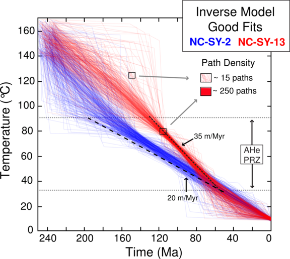
1996). (b) Detrital AHe data from New England, representative of
an Appalachian-wide data set that argues for broad cooling of the rocks
at the surface at 100 Ma. (c) Unsteadiness in post-orogenic
Appalachian erosion reconstructed from (a) and expressed as the flux of
eroded rock (left axis) and erosion rate (right axis) for a contributing
basin equal to the modern Atlantic Slope watershed of 300,000 km2
(Pazzaglia and Brandon, 1996). The shaded region under the curve amounts
to 2 km equivalent of rock removed from the Appalachians which
represents all of Cenozoic, and a small portion of the Cretaceous
section shown in the transparent window in (a). Accounting for
dissolution of ~10m/m.y. over the past 100 m.y., 1 km of rock has been
dissolved, added to 2 km of rock by erosion, sums to 3 km of rock
removed in 100 m.y. Thus, the BCT and thermochronologic data agree
in the total amount of post-orogenic erosion; however, even the AHe data
are insensitive to the nearly order of magnitude variation in erosion
unsteadiness in the past 100 Ma. Unsteadiness may be linked to
lithospheric processes like (d) margin flexure (Pazzaglia and Gardner,
2000, BR = Blue Ridge, AE = Allegheny Escarpment, CFA = Cape Fear Arch,
NA = Norfolk Arch, SE = Salisbury Embayment), or (e) geomorphic
unsteadiness in the westward migration of the continental divide (Harbor
and Gunnell, 2007) driven by sub-lithospheric dynamic mantle flow (Forte
et al., 2008; Moucha et al., 2008).
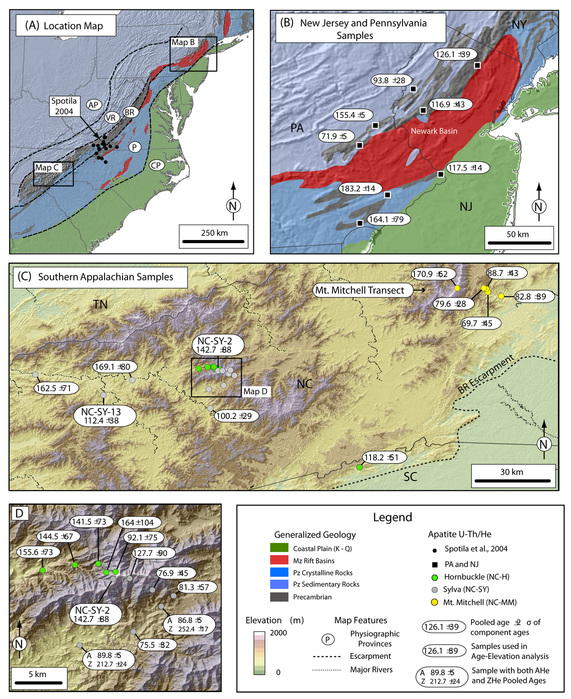
One recent
effort has been spearheaded by Ryan McKeon as his Ph.D. work.
The maps on the left
summarize AHe cooling ages for the Appalachians. The graph on the right are modeled cooling paths
for a valley bottom (red) and ridge top (blue) in the Plott Balsams
range in the Southern Blue Ridge. We would interpret a growth in
relief of this landscape of ~15 m/Ma during the Cretaceous, when the
samples experienced different cooling rates. See McKeon et al.,
2013 for all data and details.
Our most recent publication follows from the McKeon et
al work and explores the retreat of continental divide through the
Appalachian Mountains using a novel update to the filtering of
topography (Wegmann et al., 2007) to find the regional, tectonic slopes
that control drainage topology.
Papers
Pazzaglia, F. J., 1993,
Stratigraphy, petrography, and correlation of late Cenozoic middle
Atlantic Coastal Plain deposits: Implications for late-stage passive
margin geologic evolution, Geol. Soc. of Am. Bull., v.105, p.1617-1634.
PDF
Pazzaglia, F. J. and Gardner, T. W., 1994, Late Cenozoic flexural
deformation of the middle U.S. Atlantic passive margin: Journal of
Geophysical Research, v. 99, n. B6, p. 12,143-12,157. PDF
Pazzaglia,
F. J. and Brandon, M. T., 1996,
Macrogeomorphic evolution of the post-Triassic Appalachian Mountains
determined by deconvolution of the offshore basin sedimentary record:
Basin Research, 8, 255-278. PDF
Pazzaglia,
F. J., Robinson, R., and Traverse, A., 1997,
Palynology of the Bryn Mawr Formation (Miocene): Insights on the age and
genesis of middle Atlantic margin fluvial deposits: Sedimentary Geology,
v. 108, p. 19-44. PDF
Pazzaglia,
F. J. and Gardner, T. W., 2000,
Late Cenozoic large-scale landscape evolution of the U.S. Atlantic
passive margin, in Summerfield, M. ed., Geomorphology and Global
Tectonics: John Wiley, New York, p.283-302. PDFPDF
Pazzaglia,
F. J., 2003, Landscape
evolution models, in Gillespie, A. R., Porter, S. C., and Atwater, B.
F., eds., The Quaternary Period in the United States: Amsterdam,
Elsevier, p. 247-274, doi:10.1016/S1571-0866(03)01012-1. PDF
Pazzaglia et al, 2006,
Rivers, glaciers, landscape evolution and active tectonics of the
central Appalachians, Pennsylvania and Maryland: Geological Society of
America Field Guide 8, p. 169-197. PDF
Frankel et al., 2007,
GSABulletin, Knickpoint evolution in a vertically-bedded substrate,
upstream-dipping terraces, and Atlantic Slope bedrock channels. PDF
McKeon, R. E., Zeitler, P. K., Pazzaglia,
F. J., Idleman, B. D., and Enkelmann, E., 2013
Decay of an old orogen: Inferences about Appalachian landscape evolution
from low-temperature thermochronology: GSABull,
doi:10.1130/B30808.1 PDF
Moodie, A. J., Pazzaglia, F. J., and
Berti, C., 2017, Eogenic forcing and autogenic processes on
continental divide location and mobility: Basin Research, 30,
344-369. PDF
Summary: The Italian
Apennines offer a great natural laboratory to investigate concurrent
crustal shortening and extension in an uplifted forearc where the basic
geologic and structural relationships are well known. From 2003
through 2008, an interdisciplinary and international geologic, tectonic,
thermochronologic, geodynamic, geomorphic, geophysical, and geodetic
team are focused on understanding the subducted slab rollback process
and it role in creating mountainous topography during or following the
major phase of crustal thickening. The geomorphic experiment
targeted several rivers, particularly the Reno River, where terrace
mapping, fault mapping, geodetics, and cosmogenically-determined ages
and erosion rates demonstrated continued shortening in the Apennine
pro-wedge. This shortening is accommodated by deep underplating
and highly localized thrust and normal faults at shallower crustal
levels both of which are occurring rear of the deformation front.
We continue to test the possibility that deformation has followed this
out-of-sequence behavior because the thrust front has been buried by
Quaternary sediment overfilling the Po foreland, thus reducing the
critical taper of the wedge. The project is now complete, but
collaborations, spin-off, and publications continue. My main
collaborators in this project were, and continue to be Mark Brandon, Sean
Willett, Vincenzo
Picotti, Darryl
Granger, Darrel
Cowan, Martha
Cary Eppes, Karl
Wegmann, Rick
Bennett,Mauro
Coltorti, Francesco
Dramis, Paola
Molin,
Matteo Spagnolo,
Alessio Ponza, Pier
Paolo Bruno, Alessandra
Ascione, and Mimmo
Capolongo.
Left figure: Color DEM of Italy and
surrounding sea bathymetry. Middle figure: River terraces
preserved along the Reno River near Bologna. Right Figure:
Contact between terrace gravel and bedrock.
Left figure: Terrace and
fault map for the Reno valley; Middle figure: correlation of deformed
strata across the Apennine mountain front near Bologna; Right figure:
Colfiorito - the site of the 1997 "Assisi" Earthquake
Interpretation of a high resolution
seismic line that we have collected across the Bologna mountain front
near Ponte Ronca. We have since reprocessed the data resulting
in better reflectors and a new interpretation. A paper
describing this line and our findings is in prep.
Terrace map produced by M.S. student Luke Wilson.
Friends, co-workers, and cool places in the
Reno valley.
Papers:
Molin, P., Pazzaglia, F. J., and
Dramis, F., 2004, Geomorphic
expression of active tectonics in a rapidly-deforming forearc, Sila
Massif, Calabria, southern Italy: American Journal of Science, v. 304,
p. 559-589. PDF
Spagnolo, M. and Pazzaglia, F. J., 2005, Testing the geological
influences on the evolution of river profiles: A case from the northern
Apennines (Italy): Geogr. Fi. Dinam. Quat., 28, 103-113. PDF
Frankel, K. L. and Pazzaglia, F. J., 2005, Tectonic geomorphology,
drainage basin metric, and active mountain fronts: Geogr. Fi. Dinam.
Quat., 28, 7-21. PDF
Picotti, V. and Pazzaglia, F. J., 2008, A new active tectonic model
for the construction of the Northern Apennines mountain front near
Bologna (Italy): Journal of Geophysical Research, 113,
doi:10.1029/2007JB005307. PDF
Eppes, M. C., Bierma, R., Vinson, D., and
Pazzaglia, F. J., 2008, A soil
chronosequence study of the Reno valley, Italy: insights into the
relative role of climate verses anthropogenic forcing on hillslope
processes during the mid-Holocene: Geoderma, 147, 97-107. PDF
Wilson, L., Pazzaglia, F. J., Anastasio, D.
J., 2009, A fluvial record of
active fault-propagation folding, Salsomaggiore anticline, northern
Apennines, Italy: Journal of Geophysical Research, 114,
doi:10.1029/2008JB005984.
PDF
Picotti, V., Ponza, A., and Pazzaglia, F.
J., 2009, Topographic expression
of active faults in the foothills of the northern Apennines:
Tectonophysics, 474, 285-294.
PDF
Wegmann, K. W. and Pazzaglia, F. J., 2009,
Late Quaternary fluvial terraces of the Romagna and Marche Apennines,
Italy: Climatic, lithologic, and tectonic controls on terrace genesis in
an active orogen: Quaternary Science Reviews, 28, 137-165,
doi:10.1016/j.quascirev.2008.10.006. PDF
Ponza, A., Pazzaglia, F. J., and Picotti, V.,
2010, Thrust-fold activity at the
mountain front of the northern Apennines (Italy) from quantitative
landscape analysis: Geomorphology, 123, 211-231. PDF
Bruno, P. P., Pazzaglia, F. J., and Picotti,
V., 2011, High-resolution shallow
imaging of the northern Apennines mountain front near Bologna, Italy,
using wide-aperature shallow seismic reflection data: Geophysical Research
Letters, 38, L16302, doi:10.1029/2011GL047828. PDF
Ferraris, F., Firpo, M., and Pazzaglia, F.
J., 2012, DEM analyses and
morphotectonic interpretation: The Plio-Quaternary evolution of the
eastern Ligurian Alps, Italy: Geomorphology, doi:
10.1016/j.gemorph.2012.01.009. PDF
DiNaccio, D., Boncio, P., Brozzetti, F.,
Pazzaglia, F. J., and Lavecchia, G., 2013,
Morphotectonic analysis of the Lunigiana and Garfagnana grabens (northern
Apennines, Italy): Implications for active normal faulting: Geomorphology,
201, 293-311. PDF
Giachetta, E., Refice, A., Copolongo, D.,
Gasparini, N., and Pazzaglia, F. J., 2014,
Orogen-scale drainage network evolution and response to erodibility
changes: insights from numerical experiments: Earth Surface Processes and
Landforms, 39, 1259-1268. PDF
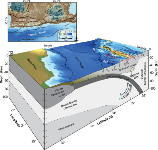
Summary: The
island of Crete rises precipitously out of the south-central
Mediterranean Sea to peak elevations of ~ 2400 m. It is the
highest-standing part of the Hellenic forearc, and active, north-verging
subduction zone accommodating the convergence of Europe and
Africa. By all conventional thinking, the forearc should be
high-standing because of crustal thickening linked to the
convergence. So what are the only faults that can be easily found
and described on Crete both high angle and low-angle normal
faults? We suspect that the easily mapped faults reflect crustal
thinning at shallow levels in response to a deeper-seated inflation
driven by underplating. We are in the process of testing this
hypothesis through a geomorphic and geodetic study of uplifted marine
terraces that tend to be very well preserved along the western and
southern coast of the island. We are also investigating the origin
of a large earthquake in 365 AD that left a distinct bath-tub ring
notch around much of the island. My collaborators with me on this
project are Karl
Wegmann, Sean
Gallen, Mark
Brandon, and Babbis
Fassoulas.
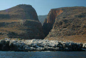
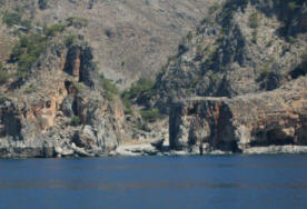
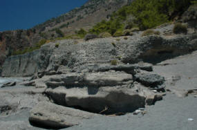
Marine terraces in Crete are
pretty spectacular.
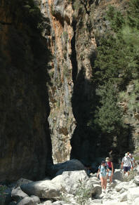
And the gorges are gorgeous.
This is a great figure from the Gallen et al.
2014 paper that shows the tectonic setting of the Crete
forearc high.
Papers:
Gallen, S. F., Wegmann, K.
W., Bohnenstiehl, Pazzaglia, F. J., Brandon, M. T., and Fassoulas, C.,
2014, Active simultaneous
uplift and margin-normal extension in a forearc high, Crete, Greece:
Earth and Planetary Science Letters, 398, 11-24. PDF
Ott,
R., Wegmann, K. W., Gallen, S. F., Pazzaglia,
F.
J., Brandon, M. Kosuke, U., and
Fassoulas, C., 2021, Reassessing Eastern Mediterranean tectonics and
earthquake hazard from the AD 365 earthquake: AGU
Advances, doi:10.1029/2020AV000315.
Summary: There has been an
explosion in the industry of "stream restoration" with the emphasis
placed on channel reaches that either are aesthetically unpleasing,
ecologically dysfunctional, or simply do not contain the desired density
of fish. There is another way to approach the interaction of
rivers and people and it involves (1) building a deep-time and historic
record of channel behavior, (2) documenting channel geometry in the
context of the entire watershed, and (3) carefully quantifying how
discharge scales with drainage area. We have discovered that the
often-cited assumption that discharge scales linearly with drainage area
is not true for watersheds under strong urban/suburban development
pressure. This is the first indication, to our knowledge for a
simple quantitative link between discharge characteristics and land
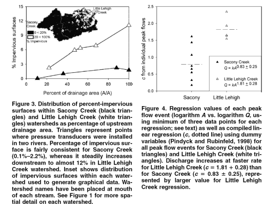
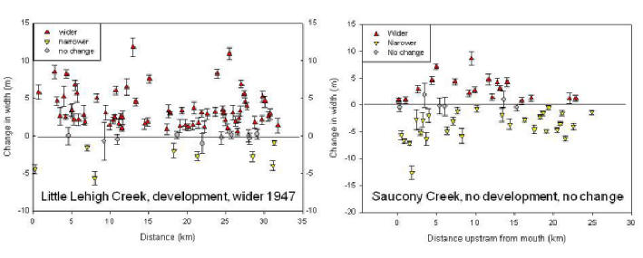
developmental pressure.
These results have lead us to begin
thinking about how carbon is fixed, sequestered, metabolized, and
transported in watersheds. Particularly, we are taking advantage
of natural (virgin) and impacted watersheds in Pennsylvania to develop a
biogeomorphologic model of these fluxes and processes. My collaborators on these projects are Josh
Galster, Chris
Dempsey, Patrick Belmont, Don Morris, Bruce
Hargreaves, Ben
Felzer, and Steve
Peters.
Papers:
Galster et al., 2006,
Effects of urbanization on watershed hydrology: The scaling of discharge
with drainage area: Geology, v. 34, p. 713-716. PDF
Galster, J. C., Pazzaglia, F. J., and Germanoski, D.,
2008, Measuring the impacts of
watershed urbanization on channel widths using historic aerial
photographs and modern surveys: JAWRA, 44, 1-13. PDF
Belmont, P.,
Morris, D. P., Pazzaglia, F. J., and Peters, S. C., 2009,
Penetration of ultraviolet radiation in streams of eastern Pennsylvania:
Topographic controls and the role of suspended particulates: Aquatic
Sciences, DOI 10.1007/s00027-009-9120-7. PDF
Dempsey, C. M.,
Morris, D. P., Pazzaglia, F. J., Peters, S. C., and O'Connor, B.,
submitted, Linking soils to streams: Using organic carbon age and
dissolved organic carbon biolability during storm events:
Biogeochemistry.
Summary: I have a long-standing
interest in Rocky Mountain Geology and Geomorphology and continue to
participate in many projects, many of which are unfunded, but
nevertheless continue to interest students. I have some key
partners in this researchat
the University of New Mexico. I also am piggy-backing some of this
research on my yearly migration west for
Lehigh Field Camp. The research is being conducted in New
Mexico (Rio Grande rift), Wyoming, Idaho, and Montana, (including
Yellowstone-Grand Teton National Parks).
The Rio Grande rift is one of only a handful
of continental rifts in the world. The rift flanks and basin fill
are very well exposed providing an outstanding natural laboratory for
the study of active tectonics, tectonic geomorphology, and Neogene basin
stratigraphy. These research topics have a broad general interest
and important applied overtones as they pertain directly to issues that
affect people. A large percentage of the population base in the
American Southwest lives on or around the Rio Grande - one of the few
perennial water sources. The tectonic evolution of the rift has
controlled the architecture and hydrology of the aquifer that supplies
large cities like Albuquerque, NM. Only through and integration of
the geomorphology, paleontology, and sedimentology of the basin fill
have we finally begun to get a handle on the complex rift-basin
stratigraphy. Further studies, some of which are in progress, are
beginning to characterize the seismic hazards of having large population
centers in this tectonically active setting.
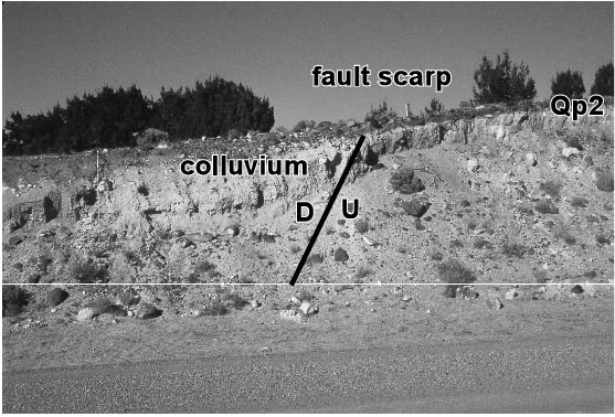
This
is
a photograph of a Quaternary fault scarp on the Borrego Canyon Road on
Zia Pueblo. The fault is just one of many that strike generally
north-south along the western flank of the rift. Although there
are no written or oral traditions which speak to seismic activity in
this region, the fault clearly cuts Quaternary gravels thought to be
middle Pleistocene age. Perhaps the recurrence times for these
faults exceed the history of continuous human occupation for this region
which is at least 1000 yrs.
This
is
a photograph of La Ceja (the eyebrow), an imposing north-facing
escarpment where the basin fill which comprises the aquifer beneath
Albuquerque is well-exposed. Several years of mapping and detailed
sedimentologic and stratigraphic work has brought us alot closer to
understanding the geomorphic and sedimentologic response to
tectonics. This understanding lies at the core of current and
future studies which are aimed at providing the answers to how to
effectively manage a dwindling ground water resource as the population
base of the rift continues to grow. One of the important
accomplishments of this collaborative research between UNM, the New
Mexico Bureau of Mines and Mineral Resources, the U.S. Geological
Survey, the American Museum of Natural History, and the Pueblos of Jemez
and Zia has been a redefinition of the basin fill stratigraphy..
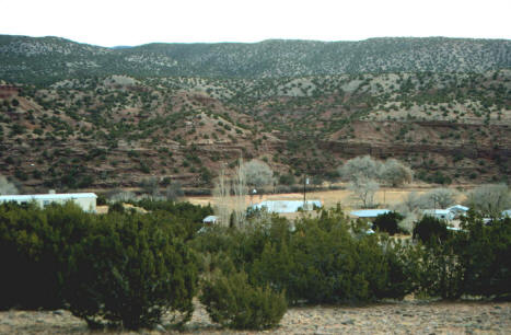
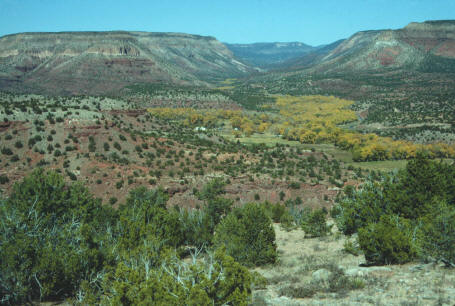
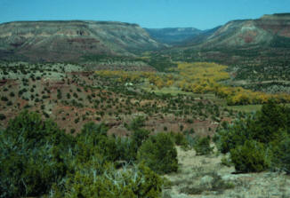
Here are some great views of the Jemez
valley where the successive mapping of John Rogers, Merri Lisa
Formento-Trigilio, Kurt Frankel, and Amanda Ault have defined a
wonderful terrace stratigraphy. The relationship of the correlated
terrace profiles (if we've done it right, we are still learning!) to the
river long profile reveals the complex interactions between base level
fall, climate-induced changes in stream concavity, and Jemez caldera
uplift.
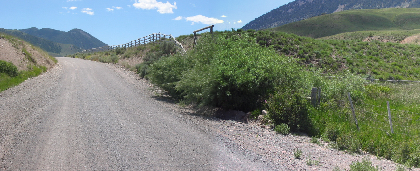
Field work in Montana includes investigations of the
active range front fault of the Tendoy Mountains, shown here crossing
Big Sheep Creek (upper photo), a great base camp up McKnight Canyon
(left), and river terraces along Big Sheep Creek (right).
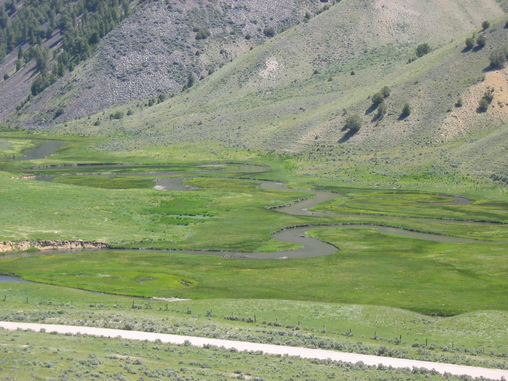
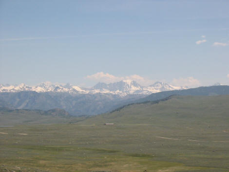
Wind River Range in western
Wyoming. I am interested in working on the age and genesis of the
sub-summit surface and linking its origin to the Green River basin
stratigraphy.
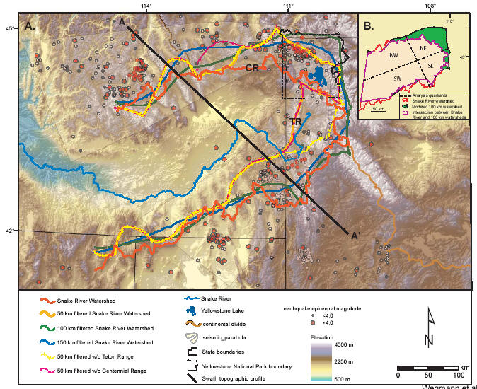
Recently, as a class project, a group
of graduate students tackled the subject of dynamic topography and used
Yellowstone as the key example of epeirogenic uplift and its geomorphic
expression. That project resulted in a publication (Wegmann et
al., 2007) and has spurred our interest to continue pursuing our
understanding of crustal deformation processes away from plate
boundaries.
Here are the results of a follow-up study where we
shot a reflection line across the Centennial Valley, with P.Paolo Bruno
and Claudio
Berti.
(Left) Location of
reflection line across the central Centennial Valley in the context of
the local geology and tectonics. (Right) Depth-migrated
reflection profile, similarity attribute, energy attribute, and
stratigraphic interpretation.
Papers:
Pazzaglia, F. J. and Wells, S. G., 1990, Quaternary
stratigraphy, soils, and geomorphology of the northern Rio Grande rift:
New Mexico Geological Society Guidebook 41, 423-430. PDF
Pazzaglia, F. J. and Kelley, S. A., 1998,
Large-scale geomorphology and fission-track thermochronology in
topographic and exhumation reconstructions of the southern Rocky
Mountains, in Karlstrom, ed., Lithospheric evolution of the Rocky
Mountains: Rocky Mountain Geology, v. 33, n.2, p. 229-257. PDF
Karlstrom, K. E. et al., including Pazzaglia, F. J., 2002, Structure and Evolution of the
Lithosphere Beneath the Rocky Mountains: Initial Results from the CD-ROM
Experiment: GSAToday, v. 12, n. 3, p. 4-10. PDF
Koning, D. J., Connell, S. D., Pazzaglia, F. J., and
McIntosh, W. C., 2002,
Redefinition of the Ancha Formation and Pliocene-Pleistocene deposition
in the Santa Fe embayment, north-central New Mexico: New Mexico Geology,
v. 24, n. 3., p. 75-87. PDF
Roy, M., Kelley, S. A., Pazzaglia,
F. J., Cather, S., and House, M., 2004,
Middle Tertiary buoyancy modification and its relationship to rock
exhumation, cooling, and subsequent extension at the eastern margin of
the Colorado Plateau: Geology, v. 32, p. 925-928. PDF
Harkins, N. W., Anastasio, D. J., and Pazzaglia, F.
J., 2005, Tectonic
geomorphology of the Red Rock fault, insights into segmentation and
landscape evolution of a developing range front normal fault: Journal of
Structural Geology, v. 27, p. 1925-1939. PDF
Regalla, C. A., Anastasio, D. J., and Pazzaglia, F. J., 2007,
Characterization of the Monument Hill Fault system and implications for
the active tectonics of the Red Rock Valley, southwestern Montana:
Journal of Structural Geology, 29, 1339-1352. PDF
Frankel, K. L. and Pazzaglia, F. J., 2006,
Mountain fronts, base
level fall, and landscape evolution: Insights from the southern Rocky
Mountains, in Willett, S. D., Hovius, N., Brandon, M. T., and Fisher, D.
eds., Tectonics, climate, and landscape evolution: Geological Society of
America Special Paper 398, p. 419-434PDF
Pazzaglia, F. J. and Hawley, J. W., 2004,
Neogene (rift flank) and Quaternary geology and Geomorphology in, Mack,
G. and Giles, K., eds., The Geology of New Mexico: New Mexico Geological
Society Special Publication 11, Albuquerque, NM, p. 407-437. PDFPDF
Wegmann, K. W., Zureck, B. D., Regalla, C. A.,
Bilardello, D., Wolleburg, J. L., Kopczynski, S. E., Ziemann, J. M.,
Haight, S. L., Apgar, J. D., Zhao, C., and Pazzaglia, F. J., 2007,
Position of the Snake River watershed divide as an indicator of
geodynamic processes in the greater Yellowstone region, western North
America: Geosphere, v. 3, p. 272-281. PDF
Anastasio, D. J., Majerowicz, C. N., Pazzaglia, F. J.,
and Regalla, C. A., 2010, Late
Pleistocene Holocene ruptures of the Lima Reservoir fault, SW Montana:
Journal of Structural Geology, 32, 1996-2008,
doi:10.1016/j.jsg.2010.08.012. PDF
Pazzaglia,
F. J., 2005, River responses to
Ice Age (Quaternary) climates in New Mexico, in Lucas, S. G., Morgan, G.
S., and Zeigler, K. E., eds., New Mexicos Ice Ages: New Mexico Museum
of Natural History and Science Bulletin No 28., p. 115-124. PDF
Bruno, P. P., Berti, C., and Pazzaglia, F. J., 2019, Accommodation, slip inversion, and
fault segmentation in a province-scale shear zone from
high-resolution, densely spaced wide-aperture seismic profiling,
Centennial Valley, MT, USA: Scientific Reports, 9:9214,
https://doi.org/10.1038/s41598-019-45497-1.
Geologic mapping has always been a
important part of my research and the research of my students. All
of the above projects have strong mapping components. In addition,
we have begun a pilot project to link geologic mapping with broader
educational and public outreach goals in mind. Through cooperation
and funding with STATEMAP and EDMAP programs, we have mapped Lehigh
Gorge State Park (PA) and developed a web, inquiry-based, interactive,
educational exercise that can be used by middle school science teachers
in an Earth Science curriculum. I current am doing most of my
mapping in collaboration with Dave
Anastasio and his students, Claudio
Berti, and
Mark Carter. The central Virginia seismic zone has been the
focus of my most recent mapping efforts.
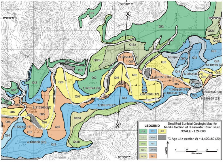
Example of a surficial geologic map of
river terraces, Clearwater River, Washington State. Mapping by
Karl Wegmann, see Wegmann
and Pazzaglia, 2002.
Ponderosa, New Mexico 7.5 minute
quadrangle surficial geologic map draped on digital shaded
topography. Mapping by Kurt Frankel. See
Frankel, 2002. Full
reference
Part
of the surficial geologic map of the Ferncliff and Pendleton 7.5 minute
quadrangles, mapped by M.S. student Helen Malenda for
EDMAP Project G13AC0015.


 Left to Right: Example of growth strata exposed in the Stirone River,
variability in magnetic susceptibility and the geomagnetic time scale,
and Milankovitch-tuned folding unsteadiness.
Left to Right: Example of growth strata exposed in the Stirone River,
variability in magnetic susceptibility and the geomagnetic time scale,
and Milankovitch-tuned folding unsteadiness.


 This
is
a photograph of a Quaternary fault scarp on the Borrego Canyon Road on
Zia Pueblo. The fault is just one of many that strike generally
north-south along the western flank of the rift. Although there
are no written or oral traditions which speak to seismic activity in
this region, the fault clearly cuts Quaternary gravels thought to be
middle Pleistocene age. Perhaps the recurrence times for these
faults exceed the history of continuous human occupation for this region
which is at least 1000 yrs.
This
is
a photograph of a Quaternary fault scarp on the Borrego Canyon Road on
Zia Pueblo. The fault is just one of many that strike generally
north-south along the western flank of the rift. Although there
are no written or oral traditions which speak to seismic activity in
this region, the fault clearly cuts Quaternary gravels thought to be
middle Pleistocene age. Perhaps the recurrence times for these
faults exceed the history of continuous human occupation for this region
which is at least 1000 yrs. 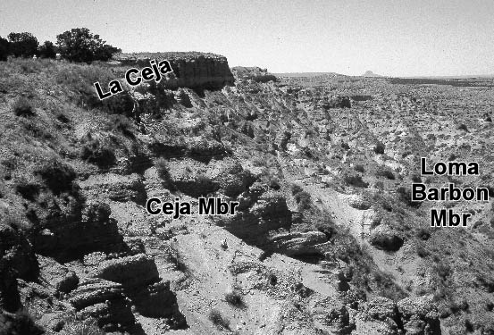 This
is
a photograph of La Ceja (the eyebrow), an imposing north-facing
escarpment where the basin fill which comprises the aquifer beneath
Albuquerque is well-exposed. Several years of mapping and detailed
sedimentologic and stratigraphic work has brought us alot closer to
understanding the geomorphic and sedimentologic response to
tectonics. This understanding lies at the core of current and
future studies which are aimed at providing the answers to how to
effectively manage a dwindling ground water resource as the population
base of the rift continues to grow. One of the important
accomplishments of this collaborative research between UNM, the New
Mexico Bureau of Mines and Mineral Resources, the U.S. Geological
Survey, the American Museum of Natural History, and the Pueblos of Jemez
and Zia has been a redefinition of the basin fill stratigraphy..
This
is
a photograph of La Ceja (the eyebrow), an imposing north-facing
escarpment where the basin fill which comprises the aquifer beneath
Albuquerque is well-exposed. Several years of mapping and detailed
sedimentologic and stratigraphic work has brought us alot closer to
understanding the geomorphic and sedimentologic response to
tectonics. This understanding lies at the core of current and
future studies which are aimed at providing the answers to how to
effectively manage a dwindling ground water resource as the population
base of the rift continues to grow. One of the important
accomplishments of this collaborative research between UNM, the New
Mexico Bureau of Mines and Mineral Resources, the U.S. Geological
Survey, the American Museum of Natural History, and the Pueblos of Jemez
and Zia has been a redefinition of the basin fill stratigraphy..